

Great Loop Chronicles Part 16
Marine
- Sponsor
- OPTIMA Batteries
- Location
- Iuka, MS


The Great Loop Chronicles will be an ongoing series, following the travels of OPTIMA Batteries staffer, Jim McIlvaine, as he travels America's Great Loop, a 6000+ nautical mile journey around the Eastern United States.
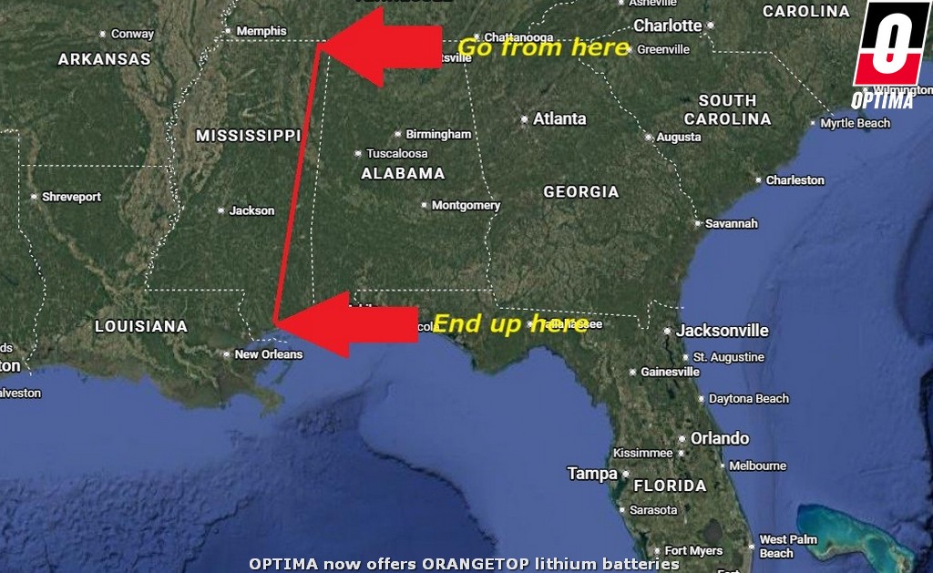
I think it's safe to say Gwendolyn and the kids exhausted every possible sightseeing opportunity during our time in Iuka, Mississippi. In addition to the sites previously mentioned, that list now includes Helen Keller's birthplace, the Rattlesnake Saloon, the Natchez Trace trail (which we've been on part of before) and the Coon Dog Cemetery. We finally made way for Bay Springs Marina on Friday, April 3rd, leaving us exactly seven days to make it down the Tombigbee Waterway and over to Pass Christian, Mississippi, before I had to leave for OPTIMA's Ultimate Street Car series in New Orleans.
The distance is approximately 450 nautical miles, so we'd need to put in a series of 60+ mile days to make it, but it was doable. That also doesn't include several more locks we'll need to make our way through. In a best-case scenario that probably adds 30-40 minutes to our travel time for each lock. I might've suggested I started flying the AGLCA burgee earlier on the trip, but the videos on my phone indicate I started flying it after we left Iuka, which served as our official entry into the Great Loop route. That means we traveled about 250 nautical miles just to get to the Great Loop from where we bought the boat.
Some people have been giving me a hard time for describing some of our earlier travels as being on the "Tennessee/Tombigbee," indicating we were not yet on the Tombigbee, but for people who don't live in the immediate area, many refer to that river system as the "Tennessee/Tombigbee' or the "Tenntom" for short. The Tombigbee portion does originate just South of Safe Harbor Aqua Yacht. Some people refer to the Tombigbee as "the ditch," because portions are a man-made canal system.
Water depth is around 15 feet deep in those sections and the system is generally wide enough for two barges to pass each other, although I'm sure people on pleasure boats passing barges find it a bit narrow in spots. The upper portion is primarily in Mississippi, but the lower portion is primarily in Alabama, where it empties out into Mobile Bay. We're basically running the length of the state of Mississippi, which can be done in a car in a matter of hours, but by boat is a different story.
Some of the notes on this section of the route suggested contacting the lockmaster the day before and trying to get through first thing in the morning or risk having to wait two hours for commercial traffic. After waiting four and a half hours the week before, we wanted to part of that and made plans for an early morning departure. Read about our next day here.
I think it's safe to say Gwendolyn and the kids exhausted every possible sightseeing opportunity during our time in Iuka, Mississippi. In addition to the sites previously mentioned, that list now includes Helen Keller's birthplace, the Rattlesnake Saloon, the Natchez Trace trail (which we've been on part of before) and the Coon Dog Cemetery. We finally made way for Bay Springs Marina on Friday, April 3rd, leaving us exactly seven days to make it down the Tombigbee Waterway and over to Pass Christian, Mississippi, before I had to leave for OPTIMA's Ultimate Street Car series in New Orleans.
The distance is approximately 450 nautical miles, so we'd need to put in a series of 60+ mile days to make it, but it was doable. That also doesn't include several more locks we'll need to make our way through. In a best-case scenario that probably adds 30-40 minutes to our travel time for each lock. I might've suggested I started flying the AGLCA burgee earlier on the trip, but the videos on my phone indicate I started flying it after we left Iuka, which served as our official entry into the Great Loop route. That means we traveled about 250 nautical miles just to get to the Great Loop from where we bought the boat.
Some people have been giving me a hard time for describing some of our earlier travels as being on the "Tennessee/Tombigbee," indicating we were not yet on the Tombigbee, but for people who don't live in the immediate area, many refer to that river system as the "Tennessee/Tombigbee' or the "Tenntom" for short. The Tombigbee portion does originate just South of Safe Harbor Aqua Yacht. Some people refer to the Tombigbee as "the ditch," because portions are a man-made canal system.
Water depth is around 15 feet deep in those sections and the system is generally wide enough for two barges to pass each other, although I'm sure people on pleasure boats passing barges find it a bit narrow in spots. The upper portion is primarily in Mississippi, but the lower portion is primarily in Alabama, where it empties out into Mobile Bay. We're basically running the length of the state of Mississippi, which can be done in a car in a matter of hours, but by boat is a different story.
Some of the notes on this section of the route suggested contacting the lockmaster the day before and trying to get through first thing in the morning or risk having to wait two hours for commercial traffic. After waiting four and a half hours the week before, we wanted to part of that and made plans for an early morning departure. Read about our next day here.