

Great Loop Chronicles Part 20
Marine
- Sponsor
- OPTIMA Batteries
- Location
- Mobile, AL


The Great Loop Chronicles will be an ongoing series, following the travels of OPTIMA Batteries staffer, Jim McIlvaine, as he travels America's Great Loop, a 6000+ nautical mile journey around the Eastern United States.
Bobby's Fish Camp is a nautical remote outpost because of the amount of water you need to cover just to get there from the last marina and the amount of water you need to cover to get to the next marina. We woke up on a Wednesday morning at Bobby's, knowing I needed to leave for the OPTIMA Ultimate Street Car series weekend in New Orleans on Friday morning.
I wasn't interested in making any top speed runs to reach our destination, because that's just too expensive of a way to travel the Loop, but I felt if we took advantage of all the daylight we could, we'd still cover a lot of water. We'd need to cover over 100 miles that day, to get to The Grand Mariner in Mobile Bay, but it would start with making our way through the Coffeeville Lock, our last lock...for at least a few hundred miles.
I tried running at 1,400 rpms, which gave us an average speed of 9.5 knots. How did I arrive at that particular speed? Garmin gives you an ETA of when you will arrive at your destination, based on your current speed. The sun sets in Mobile, Alabama at 7:16PM, but I wanted to give myself a cushion, just in case we had delays or trouble finding the marina.
We were up and moving down river by 6:30AM and based on the MarineTraffic app, we were through the Coffeeville Lock before our boat buddies, the Mackeys, had left Bobby's Fish Camp. Their destination was further West- New Orleans, so they were going to be running faster than us and it didn't take long for them to catch up. Paul's son, Scott was behind the wheel and neither of us had any experience with boats of these sizes (52 feet and 46 feet) overtaking each other in relatively tight quarters on a river.
Scott slowed down a bit but was still going a couple miles an hour faster and I figured that would be fine. It wasn't. I didn't get turned into their wake quickly enough and we went a rocking and a rolling! It made Gwendolyn pretty nervous and knocked a lot of books off shelves inside the boat, but it only lasted a few seconds. Almost immediately, both of us realized the best way to execute that pass is for me to slow down to just above idle and Scott to pass me at a slightly faster pace. Lesson learned.
One of OPTIMA's sponsored anglers, Edwin Evers told me to expect to start seeing alligators South of the Coffeeville lock as big as cars, but we didn't see a single gator all the way to Mobile Bay. My daughter did spot and identify the first palm tree along our route and we started to see more derelict boats on the shores of the riverway, including one motor cruiser, that looked like it had someone living on it, but was sitting at an angle that made it look like it had been run aground (or at least settled there on a low tide).
When you travel down the Tombigbee, you go from being surrounded by water and vegetation to transitioning into areas with ships so tall on the horizon, that it almost reminded me of how skyscrapers in Manhattan blocked the sun as you drove down the streets. While the captains moving barges might talk to you further North, we were told no one down here would acknowledge our presence unless we were in their way and/or doing something wrong.
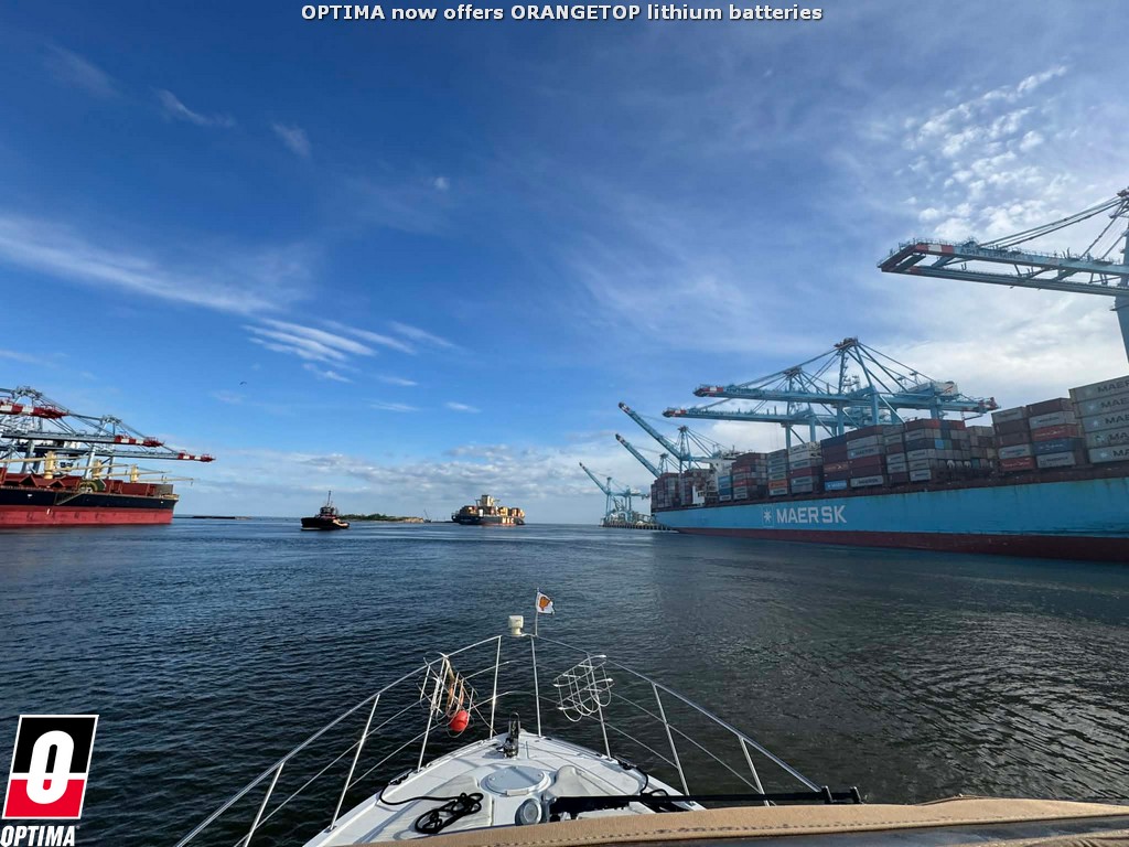
I tried to avoid any trouble, but we did pass a large freighter being pulled out to sea by a tugboat as we made our way to the Grand Mariner. It's a good thing we baked extra time into our schedule, because we had a hard time finding the Grand Mariner. Navigation may tell you how to get there, but you have to be careful not to follow the magenta navigational line into shallow water. There were clear-cut channels for shipping and I tried to stay in those, but we had a heck of a time finding the right cut that would lead us to the Grand Mariner.
We ended up going too far and had to backtrack and I had to pick up the pace to beat the sunset, but we made it to the fuel dock at 7PM, with about 15 minutes of daylight to spare. We took on 156 gallons of fuel, which means we burned a gallon every 0.76 miles. Still not great, but we were one day away from Pass Christian with one day left to get there. We also noticed the back of our boat was filthy with diesel exhaust. We had a tailwind for part of our run that day, but we'd had that on other days with no diesel mess on the stern. Did we get some bad fuel at our last stop? The boat seemed to run fine.
My wife's sister drove over from Pass Christian, picked up our kids and dropped off her husband and one of our nephews. They would be joining us on the transit to Pass Christian, but there were questions about the weather. The forecast called for wind and I wasn't confident we'd be able to make the run over to Pass Christian. Everyone has a go/no go number for various weather conditions and mine might be around 15 mph. The Mackeys had beaten us to The Grand Mariner, but they had similar concerns about the weather coming up. Would either of us take a chance? Find out here.
Bobby's Fish Camp is a nautical remote outpost because of the amount of water you need to cover just to get there from the last marina and the amount of water you need to cover to get to the next marina. We woke up on a Wednesday morning at Bobby's, knowing I needed to leave for the OPTIMA Ultimate Street Car series weekend in New Orleans on Friday morning.
I wasn't interested in making any top speed runs to reach our destination, because that's just too expensive of a way to travel the Loop, but I felt if we took advantage of all the daylight we could, we'd still cover a lot of water. We'd need to cover over 100 miles that day, to get to The Grand Mariner in Mobile Bay, but it would start with making our way through the Coffeeville Lock, our last lock...for at least a few hundred miles.
I tried running at 1,400 rpms, which gave us an average speed of 9.5 knots. How did I arrive at that particular speed? Garmin gives you an ETA of when you will arrive at your destination, based on your current speed. The sun sets in Mobile, Alabama at 7:16PM, but I wanted to give myself a cushion, just in case we had delays or trouble finding the marina.
We were up and moving down river by 6:30AM and based on the MarineTraffic app, we were through the Coffeeville Lock before our boat buddies, the Mackeys, had left Bobby's Fish Camp. Their destination was further West- New Orleans, so they were going to be running faster than us and it didn't take long for them to catch up. Paul's son, Scott was behind the wheel and neither of us had any experience with boats of these sizes (52 feet and 46 feet) overtaking each other in relatively tight quarters on a river.
Scott slowed down a bit but was still going a couple miles an hour faster and I figured that would be fine. It wasn't. I didn't get turned into their wake quickly enough and we went a rocking and a rolling! It made Gwendolyn pretty nervous and knocked a lot of books off shelves inside the boat, but it only lasted a few seconds. Almost immediately, both of us realized the best way to execute that pass is for me to slow down to just above idle and Scott to pass me at a slightly faster pace. Lesson learned.
One of OPTIMA's sponsored anglers, Edwin Evers told me to expect to start seeing alligators South of the Coffeeville lock as big as cars, but we didn't see a single gator all the way to Mobile Bay. My daughter did spot and identify the first palm tree along our route and we started to see more derelict boats on the shores of the riverway, including one motor cruiser, that looked like it had someone living on it, but was sitting at an angle that made it look like it had been run aground (or at least settled there on a low tide).
When you travel down the Tombigbee, you go from being surrounded by water and vegetation to transitioning into areas with ships so tall on the horizon, that it almost reminded me of how skyscrapers in Manhattan blocked the sun as you drove down the streets. While the captains moving barges might talk to you further North, we were told no one down here would acknowledge our presence unless we were in their way and/or doing something wrong.
I tried to avoid any trouble, but we did pass a large freighter being pulled out to sea by a tugboat as we made our way to the Grand Mariner. It's a good thing we baked extra time into our schedule, because we had a hard time finding the Grand Mariner. Navigation may tell you how to get there, but you have to be careful not to follow the magenta navigational line into shallow water. There were clear-cut channels for shipping and I tried to stay in those, but we had a heck of a time finding the right cut that would lead us to the Grand Mariner.
We ended up going too far and had to backtrack and I had to pick up the pace to beat the sunset, but we made it to the fuel dock at 7PM, with about 15 minutes of daylight to spare. We took on 156 gallons of fuel, which means we burned a gallon every 0.76 miles. Still not great, but we were one day away from Pass Christian with one day left to get there. We also noticed the back of our boat was filthy with diesel exhaust. We had a tailwind for part of our run that day, but we'd had that on other days with no diesel mess on the stern. Did we get some bad fuel at our last stop? The boat seemed to run fine.
My wife's sister drove over from Pass Christian, picked up our kids and dropped off her husband and one of our nephews. They would be joining us on the transit to Pass Christian, but there were questions about the weather. The forecast called for wind and I wasn't confident we'd be able to make the run over to Pass Christian. Everyone has a go/no go number for various weather conditions and mine might be around 15 mph. The Mackeys had beaten us to The Grand Mariner, but they had similar concerns about the weather coming up. Would either of us take a chance? Find out here.